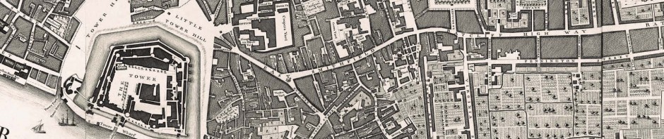
Locating London’s Past will create an intuitive GIS interface that will enable researchers to map and visualize textual and artefactual data relating to seventeenth and eighteenth-century London against a fully rasterised version of John Rocque’s 1746 map of London and the first accurate modern OS map (1869-80). More than this, it will make these data and maps available within a Google Maps container, allowing for the analysis of the data with open source visualization tools. The interface will be readily expandable to include additional data sets and maps (both modern and historic).
Building on the partnerships created through the JISC funded ‘Connected Histories’ project, and through a new collaboration with the Museum of London Archaeological Service (MOLA), Locating London’s Past will produce a working GIS-enabled public web environment that will allow existing electronic historical data about London to be repackaged and organised around space.
The project incorporates four elements. First, a fully rasterised and GIS-enabled version of John Rocque’s 1746 map of London will be created and tied to a GIS enabled version of the first reliable modern OS map (1869-80). Second, standard geo-referencing will be incorporated into some 4.9 million lines of data drawn from the Old Bailey Online, London Lives, datasets created by the Centre for Metropolitan History, and MOLA’s extensive database of archaeological finds. Third, using an API methodology, the historical GIS will be presented for public use and re-use both online and as downloads, within a Google Maps ‘container’ (giving access to satellite images, ‘street views’ etc), to facilitate ‘mash-ups’ with modern datasets (geological, flooding, land use, etc). This in turn will create an environment in which additional external historical datasets and GIS enabled historical maps can be added. Fourth, a series of open source visualization tools, with examples and documentation, will be made available through the interface to allow datasets with multiple variables about crime, social policy, taxation and material culture to be represented and analysed in conjunction with the three layers of GIS-enabled mapping (Rocque, OS, Google Maps).
By bringing within a single framework archaeological evidence of pipes and shards, and historical trial records, voting lists, insurance files and taxations records, this project will contribute to the ‘spatial turn’ in humanities and social science scholarship, not just by making geographical analysis possible, but by making it readily accessible.
